



Two deadly flood waves race down Texas Hill Country rivers as catastrophic flooding paralyzes communities
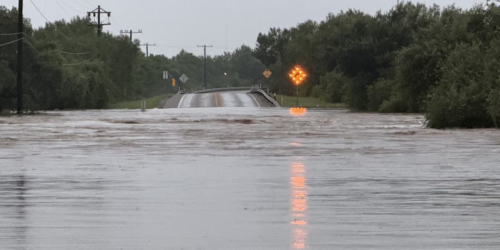

Relentless, life-threatening flash flooding is ongoing across parts of Texas' Hill Country as the National Weather Service (NWS) issued a series of warnings from before dawn through Thursday morning about "large and deadly flood waves" moving down major rivers in the region, including the Guadalupe.
SAN ANTONIO — Relentless, deadly flash flooding is ongoing across parts of Texas' Hill Country as the National Weather Service (NWS) issued a series of warnings from before dawn through Thursday morning about "large and deadly flood waves" moving down major rivers in the region, including the Guadalupe.
A flood wave is a surge of rapidly rising water that travels downstream through a river, capable of sweeping away vehicles, overtopping bridges and destroying homes in a matter of minutes.
Texas Governor Greg Abbott said Thursday one person was killed by catastrophic flooding overnight in the Kerrville area. The victim has not been identified.
KNOW YOUR FLOOD TERMINOLOGY: WHAT FLOOD WATCHES, WARNINGS AND EMERGENCIES REALLY MEAN
Last year's devastating floods killed at least 135 people in Kerrville and other vulnerable communities along the Guadalupe.
"The [Guadalupe] river gauge at Center Point has risen 32 feet in 4 hours and is expected to reach a crest similar to [the] July 4, 2025, catastrophic river flood," the NWS said in a Flash Flood Emergency warning bulletin issued just after 5:30 a.m. local time.
The NWS warned of several deadly flood waves surging down the Guadalupe and Pedernales rivers as flooding spread to the Nueces and Frio river basins through Thursday morning.
Flash Flood Emergencies were issued in the pre-dawn hours Thursday across Kerr, Kendall and Uvalde counties and have expanded through the morning to include Blanco and Gillespie counties.
Officials ordered people in low-lying areas and communities under Flash Flood Emergencies to evacuate or seek higher ground immediately, while urging everyone else to stay off the roads.
The Guadalupe River at Comfort rose more than 34 feet in less than two hours, reaching major flood state Thursday morning.
HERE'S WHAT TO DO IF YOU ENCOUNTER A FLOODED ROAD
South-central Texas has been battered by heavy rain since Monday night, with more than 2.5 million people in the bull's-eye for additional rounds of torrential rain through Friday.
Flooding forced widespread closures of state highways and local roads, according to county officials and real-time traffic maps from the Texas Department of Transportation.
Aerial rescue units were seen rejoining water rescue teams after first light.
FOX 7 Austin reported that the Comfort RV Resort was evacuated, and 10 people had to be rescued by helicopter from the roof of a barn near Kerrville Thursday morning.
Kerr County Judge Rob Kelly issued an official disaster declaration Thursday morning, while the Kerr County Sheriff's Office said it confirmed that campers at all camps in the county are safe.
The Ingram Fire Department in Kerr County said it rescued a driver whose vehicle stalled in floodwaters overnight and received additional reports of stranded vehicles.
7 FACTS YOU SHOULD KNOW ABOUT FLASH FLOODS
Kendall County officials said they performed multiple water rescues Thursday morning, while at least 68 people took shelter at county facilities during the height of the initial flooding.
Uvalde police said they have conducted at least 25 water rescues since Tuesday.
FOX Weather Senior Correspondent Robert Ray showed parts of Uvalde cut off from the rest of the city Thursday as the Taylor Slough overtopped its banks.
More than 20 inches of rain has fallen in Uvalde over the past 3 days, and police were seen going door to door evacuating neighborhoods on Wednesday morning.
A viewer in Uvalde told FOX Weather that helicopters rescued people on County Road 429 north of the city Wednesday.
A Flash Flood Emergency was issued for Kendall County on Wednesday as Boerne officials said high-water rescues were ongoing across the city, while a second Flash Flood Emergency was issued for D'Hanis in Medina County.
Within the warned area, nearly 4 to 12 inches of rain fell in the span of six hours, according to the FOX Forecast Center.
SEE IT: RADAR-CONFIRMED TORNADO TOUCHES DOWN NEAR MAJOR TEXAS CITY
Ray reported widespread washouts and roads that had been rendered impassable near Camp Wood in Real County Wednesday.
Officials from Sabinal and Medina County told FOX Weather on Tuesday they made multiple water rescues, with one driver saved by a tree that prevented their vehicle from being swept away.
FLOOD WATCH, WARNING AND EMERGENCY: HERE ARE THE DIFFERENCES THAT COULD SAVE YOUR LIFE
The torrential rain and flooding prompted Gov. Greg Abbott to declare a state of emergency for 59 counties on Tuesday.
Abbott said the Blackhawk helicopters and other rescue teams were deployed Tuesday, and the National Guard and other state resources were activated ahead of the storms.
Meanwhile, the same weather system responsible for the flooding spawned a radar-confirmed tornado in northwest San Antonio that damaged a popular shopping mall during the Wednesday morning rush.
Dramatic video near Interstate 10 in San Antonio appeared to show a tornado in the distance as traffic streamed along during the Wednesday morning rush.
WATCH: DRONE REVEALS DEVASTATING FLASH FLOODING SWEEPING THROUGH SOUTHEASTERN MISSOURI
FOX Weather Correspondent Brandy Campbell reported damage at The RIM shopping mall near where the funnel cloud was seen. It's unknown if there are any injuries.
NOAA's Weather Prediction Center (WPC) increased Thursday's flood risk to a Level 4 out of 4 flash flood risk for parts of the Texas Hill Country, with a broader Level 3 threat including the rest of Hill Country.
A Level 2 threat covers the northwestern part of the San Antonio metro area through Friday morning.
The region is forecast to see an additional 2 to 5 inches of rain through Friday.
"Localized spots could see another foot of rain or more if storms repeatedly impact the same locations," the FOX Forecast Center said.
The FOX Forecast Center noted this is the first time the WPC has issued a Level 4 flash flood risk since April 2025, when it issued Level 4 risks on three consecutive days across the Mississippi River Valley.
Flood Watches for life-threatening floods remain in place across central and southwestern Texas, including Austin, Kerrville and Del Rio through Thursday.
BRIGHT IDEA: BOLD PLAN SUGGESTS WEAKENING ONE OF EARTH'S MOST POWERFUL CLIMATE FORCES
The massive heat dome locked over the northern half of the country is forcing a weak storm system underneath it, causing steering winds higher in the atmosphere to come to a crawl. This will create an environment where a weather disturbance can spin over the western half of Texas, according to the FOX Forecast Center.
"Without a driving force to keep storms moving, downpours are expected to park themselves over the same areas day after day," the FOX Forecast Center said.
This week's flood threat also comes on the heels of a deadly flash flooding along the Black River in southeastern Missouri that began on Friday and lasted into the weekend.
Check back for updates on this developing story.
The post Two deadly flood waves race down Texas Hill Country rivers as catastrophic flooding paralyzes communities appeared first on Fox Weather