


 Classic designer bags")


 Summer of Soccer")


Severe storm threat shifts East after deadly, catastrophic flooding slams Kentucky and Indiana
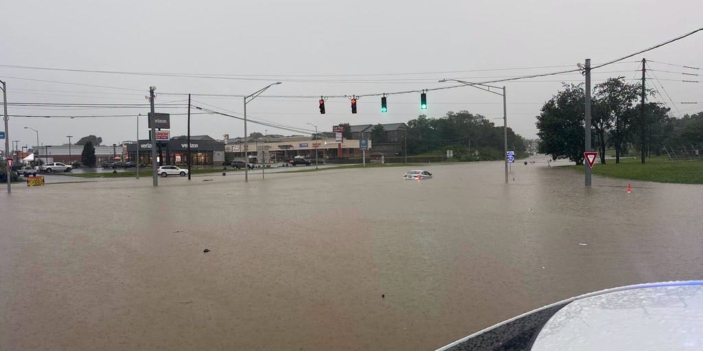
At least four people have died after rounds of dangerous flash flooding swamped the Ohio Valley on Saturday, prompting water rescues and evacuations as multiple Flash Flood Emergencies were issued in Kentucky amid a multi-day stretch of torrential rain.
KENTUCKY - There are Flash Flood Emergencies in effect in multiple Kentucky counties as downpours slam the region Sunday morning. It comes not even a day after catastrophic flooding impacted the area.
The emergencies have been issued for Clinton, Cumberland and Metcalfe counties through 11:15 a.m. CT.
At least four people have died after rounds of dangerous flash flooding swamped the Ohio Valley on Saturday, prompting water rescues and evacuations as multiple Flash Flood Emergencies were issued in Kentucky amid a multi-day stretch of torrential rain.
"We've lost three people in Madison County and one in Jackson County due to flooding," Kentucky Gov. Andy Beshear wrote on X.
Among the victims was a driver who was swept away by flash floodwaters, Beshear said.
NOT JUST HURRICANES: TROPICAL STORMS IN HISTORY THAT PACKED A PUNCH WITH HISTORIC, DEADLY FLOODING
Beshear has declared a state of emergency for the entire Commonwealth of Kentucky as widespread flooding continues to impact the state, warning that conditions are "much more severe than most would have thought."
In Richmond, Kentucky, two people were confirmed dead after a Flash Flood Emergency was issued for Madison County. Authorities believe both victims drowned in rapidly rising floodwaters.
An emergency was declared as repeated rounds of thunderstorms tracked over already saturated ground, intensifying flash flooding and creating life-threatening conditions across the county.
The FOX Forecast Center said up to 7 inches of rain fell, leading to catastrophic flooding in Jackson, Kentucky. Several high water rescues were reported along with several roads that were underwater.
In Indiana, a Flash Flood Emergency was issued for Gibson County, where there were reports of water entering homes and water rescues reported.
According to the Richmond Police Department, first responders were dispatched to the hardest-hit areas, where floodwaters had inundated homes and trapped residents inside.
Rescue crews successfully located and evacuated several residents, but were unable to make contact with occupants of a basement residence that had become completely submerged.
Once crews were able to gain entry, they discovered an adult man and an adult woman who had died. Both deaths are believed to have resulted from drowning.
A Flash Flood Emergency was issued in Jackson County for McKee, Sandgap and Clover Bottom as life-threatening flooding inundated communities on Saturday.
Photos shared by the Richmond Police Department showed roads submerged by floodwaters as emergency crews responded to numerous water rescue calls in the area.
As life-threatening flooding continues across Kentucky, local states of emergency have been declared in Bullitt, Madison, Meade, Mercer and Spencer counties.
HOW FLOODWATER CAN MAKE YOU VERY SICK
In Bullitt County, Kentucky, officials issued an urgent evacuation order for part of Lebanon Junction after a dam was reported to have suffered a "moderate" failure, according to emergency management officials.
Heavy rain also spread into Indiana, where a Flash Flood Emergency was issued for eastern Gibson County and west-central Pike County.
Most Flash Flood Warnings are expected to expire by early Sunday as the widespread flooding threat gradually eases. However, the weather won't turn completely dry.
SEVERE STORMS TARGET NORTHERN PLAINS WITH POWERFUL WINDS, LARGE HAIL THREAT HEADING INTO WORKWEEK
Even though most flood alerts will expire, scattered showers and a few embedded thunderstorms will remain across central and south-central Kentucky through Sunday afternoon.
There is a Level 3 out of 4 flash flood threat in place in Kentucky due to an area of thunderstorms that is not moving and creating numerous flash flood warnings. This time, the threat is further east compared to Saturday, according to the FOX Forecast Center.
Near-record moisture values will keep the environment unstable through the first half of the day.
Any lingering morning storms will still be able to produce torrential downpours and localized flooding once again, the FOX Forecast Center said.
By Sunday afternoon, the primary severe threat will shift to the coast, leaving a Level 1 out of 5 severe storm threat confined to southeast Virginia and eastern North Carolina.
KNOW YOUR FLOOD TERMINOLOGY: WHAT FLOOD WATCHES, WARNINGS AND EMERGENCIES REALLY MEAN
Damaging wind gusts will be the main hazard with these storms, according to the FOX Forecast Center.
For the rest of the Northeast and Mid-Atlantic, only isolated, lingering showers are expected before drier, more seasonable weather finally returns on Monday.
This brief reprieve, however, will be short-lived; a building heat dome will set the stage for oppressive, triple-digit heat indices area-wide by mid-week.
The post Severe storm threat shifts East after deadly, catastrophic flooding slams Kentucky and Indiana appeared first on Fox Weather


