
 Classic designer bags")


 Summer of Soccer")


Millions across Central US in path of damaging hail, strong winds as multi-day severe storm threat kicks off
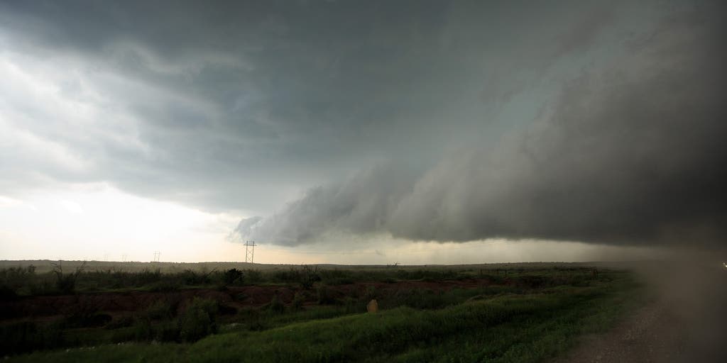
As the stagnant Omega block weather pattern wanes, the chance for new severe storm development is taking shape across the Great Plains and midwestern U.S. through the weekend.
As the stagnant Omega block weather pattern wanes, the chance for new severe storm development is taking shape across the Great Plains and midwestern U.S. through the weekend.
After days of heat across the Central U.S., the high pressure system caught in the middle will now start to flatten, allowing a series of storm systems to pour into the Plains, extending over 1,000 miles.
WHAT IS A SUPERCELL THUNDERSTORM?
This comes as regions such as central Kansas, including Wichita, are under a Level 2 out of 5 risk of severe thunderstorm risk, according to the National Oceanic and Atmospheric Administration (NOAA).
The first round of storms started Thursday afternoon as waves of weaker storms moved out of the Rockies and into the Central Plains, when a surface low is expected to develop around western Kansas, with an associated dryline extending down through Texas.
An area of high pressure will assist with pumping increasing amounts of Gulf moisture northward. This, along with record heat, will boost instability and support the development of severe storms.
With the Level 2 out of 5 severe storm threat in place for central and eastern Kansas, a larger Level 1 threat extended from the Texas panhandle through Missouri.
Nearly seven million Americans were at risk as the storms are expected to produce damaging wind gusts over 75 mph and hail over 2 inches in diameter.
HOW HIGH PRESSURE AND LOW PRESSURE DRIVE THE WEATHER
Friday will be similar to Thursday, with a Level 2 out of 5 threat in place for the same areas, and hail and strong winds being the primary threats.
The multi-day event will continue through Saturday as the system moves out of the Rockies and towards the Great Plains.
A cold front is forecast to push eastward into the Missouri Valley, calling for a level 2 out of 5 threat spanning from the Texas panhandle through portions of Nebraska, Iowa and Missouri.
WHAT IS A SUPERCELL THUNDERSTORM?
Supercells are expected to consolidate by Saturday evening, with all hazards remaining on the table, including hail up to 3 inches, damaging wind gusts and the chance of a strong tornado or two.
With heavier rain moving into portions of northern Missouri and Iowa, a low-end flash flooding risk will develop into Saturday.
Starting Sunday, a powerful, high-amplitude trough will anchor itself across the western U.S., as an area of low pressure will intensify, leading to a cold front to drape from the Upper Midwest into the Southern Plains.
Ahead of this, a surge of Gulf moisture will fuel an environment of instability.
SOUTHERN CALIFORNIA BEACHGOERS FACE FOUL SMELL AS UNTREATED WASTEWATER POLLUTES POPULAR WATERS
While a broad Level 2 out of 5 severe threat exists from the Texas panhandle through Minnesota, a Level 3 threat exists for portions of Nebraska and western Minnesota.
"The primary concern for Sunday afternoon and evening will be the development of discrete, long-lived supercells," the FOX Forecast Center said. "These storms will be capable of producing monster hail, potentially exceeding 2 to 3 inches, along with a risk for tornadoes."
WHAT IS A DRYLINE AND WHY IS ITS LOCATION IMPORTANT IN SEVERE WEATHER FORECASTING?
By Monday the severe threat will continue. An even larger Level 2 threat is expected, with more than 30 million Americans from Wisconsin through northern Texas in its path and stretching more than 1,000 miles.
Similar to Sunday, a Level 3 out of 5 threat is active across the same areas.
It is possible that extreme moisture combined with wind shear could support further development of stronger storms, but expect more wet weather to start next week.
The severe storm threat will likely expand into Tuesday as the storm system pushes east into the Ohio Valley and central U.S., with a Level 2 out of 5 threat in place from Oklahoma City through Peoria, Illinois.
7 FACTS YOU SHOULD KNOW ABOUT FLASH FLOODS
A widespread 1 to 2 inches of rain is also possible from northern Minnesota through northeast Texas, with some areas seeing more than 2 to 3 inches, increasing the risk of flash flooding early next week.
The post Millions across Central US in path of damaging hail, strong winds as multi-day severe storm threat kicks off appeared first on Fox Weather


