









Outer Banks first in line for developing nor’easter as dangerous impacts begin Wednesday
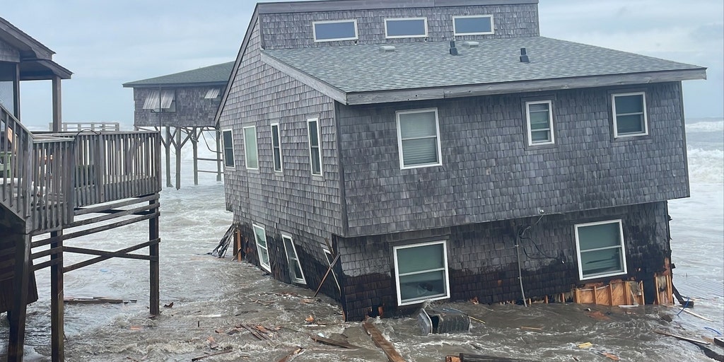


The Outer Banks are bracing for the first nor’easter of the season, with strong winds, heavy rain, dangerous surf, coastal flooding and beach erosion expected along the coast.
THE TAKEAWAY
OUTER BANKS, N.C. – The Outer Banks are getting slammed by the first nor’easter of the season, with strong winds, heavy rain, dangerous surf, coastal flooding and beach erosion expected along the coast.
North Carolina's Outer Banks will see moderate flooding, which is has already begun.
With the increasing threat to the region, officials expect hazardous travel conditions at Cape Hatteras National Seashore, a popular destination for the metro area.
WILL THE MONSTER NOR'EASTER CANCEL YOUR WEEKEND PLANS? HERE'S WHAT TO KNOW
Road conditions along the stretch of N.C. Highway 12 are vulnerable to overwash during prolonged periods of strong northeast winds and large surf slamming against the coast, according to the National Park Service.
As the surf grows more violent, it will rise 2 to 3 feet above average wave height, with no signs of fading over the next few days.
Residents and travelers in the region can expect sand and standing saltwater on roadways and other landscapes as coastal flooding inches farther inland, especially through Pea Island National Wildlife Refuge.
WHAT’S THE DIFFERENCE BETWEEN A NOR’EASTER AND A HURRICANE?
The National Weather Service expects the following impacts:
The coastal flood risk will increase throughout the workweek from the North Carolina Outer Banks to New England as strong northeasterly winds fuel severe storm conditions.
This is an especially big risk for the Outer Banks, as numerous homes along the coast have been knocked over and destroyed by coastal flooding in the past.
"Pounding wave action across multiple high-tide cycles will trigger major coastal flooding and severe beach erosion," the FOX Forecast Center said. "Ocean overwash onto coastal roadways (like Highway 12) is expected, resulting in scenes similar to last year's major coastal events."
Depending on the severity of flooding and ocean overwash, many roads may close due to the risk.
NOR'EASTER LIVE TRACKER: FUTURE RADAR, WINDS, STORM SURGE, RAIN AND ALERTS
Wind gusts will be as strong as 40 to 50 mph, fueling dangerous offshore wave heights reaching 15 to 18 feet just off the coast of the Outer Banks.
Across the entire Northeast coast, the National Weather Service has issued a High Surf Advisory, along with Coastal Flood Advisories for popular areas such as Philadelphia and a Coastal Flood Warning for Atlantic City, New Jersey.
This comes as the U.S. Coast Guard warns of gale-force winds and hazardous seas affecting the region from North Carolina to New Jersey, with sustained winds of 25 to 30 knots and gusts up to 45 knots.
TIMELINE: HERE'S WHERE AND WHEN MAJOR US CITIES WILL SEE IMPACTS FROM THE DEVELOPING NOR'EASTER
"These conditions create life-threatening beach hazards, such as dangerous rip currents and large battering waves, particularly along the coastal waters of Virginia and North Carolina," the U.S. Coast Guard said.
Authorities also suggest that you never drive through floodwaters.
"Each year, more deaths occur due to flooding than from any other thunderstorm-related hazard," the National Weather Service said.
Many people underestimate the depth and strength of water, which can sweep a vehicle downstream.
As intense wind gusts help fuel powerful surf and flooding, the nor’easter storm conditions will show little relief for thousands of Americans through the weekend.
The post Outer Banks first in line for developing nor’easter as dangerous impacts begin Wednesday appeared first on Fox Weather