










'Historic' El Niño increasingly likely, with 83% chance of becoming the strongest on record


The chances of a potentially historic El Niño are increasing as the U.S. heads into winter, according to NOAA’s latest forecast. El Niño is expected to play a significant role in determining which regions across the country will see more rain and snow.
THE TAKEAWAY:
The chances of a potentially historic El Niño are increasing as the U.S. heads into winter, according to NOAA’s latest forecast. El Niño is expected to play a significant role in determining which regions across the country will see more rain and snow this winter.
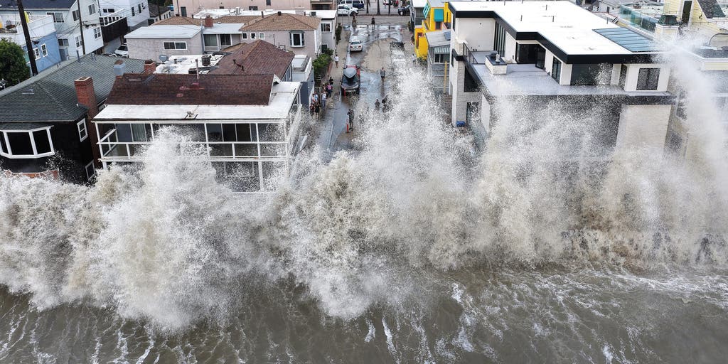
POWERFUL WAVES BATTER SOUTHERN CALIFORNIA COAST, DAMAGING HOMES AND TRIGGERING SINKHOLE
NOAA's October forecast now indicates an 83% chance that this will be the strongest El Niño since record-keeping began in 1950, up from a 75% chance last month.
WHAT’S THE DIFFERENCE BETWEEN A TROPICAL DEPRESSION, TROPICAL STORM AND HURRICANE?
El Niño is one of three phases of a climate cycle called the El Niño-Southern Oscillation (ENSO). It describes natural temperature changes in the central Pacific Ocean that alter atmospheric circulation and can greatly influence global weather.
El Niño describes warmer than average water across the equatorial Pacific, while La Niña describes colder than average water conditions, and ENSO neutral refers to a state where temperatures are close to average.
These warmer waters influence atmospheric circulation and can shift the jet stream, changing storm tracks, precipitation patterns and temperatures across the U.S.
Water temperatures in the central equatorial Pacific, averaged more than 2 degrees Celsius above normal in September, which is considered Super El Niño territory.
Temperatures have to remain 2 degrees above average for three months to officially be considered a Super El Niño event.
The current three-month average is now 1.7 degrees Celsius above average during the July-August-September time range, meaning that an official Super El Niño could be classified in NOAA's November update.
A strong El Niño is typically associated with a very active Pacific hurricane season, while suppressing the Atlantic hurricane season, a pattern that has certainly held true so far this year.
Meanwhile, El Niño is also expected to drive wetter conditions across Southern California, the Southwest and the Southeast this winter.
During a Super El Niño, the Pacific jet stream tends to become more extended and active, acting as a conveyor belt that directs storm systems across the southern tier of the U.S.
According to the latest seasonal forecast from the European computer forecast model, parts of the West and South are expected to see above-average precipitation, particularly across California, the Southwest, Texas, the Gulf Coast, the Southeast and even the Mid-Atlantic.
NOAA is expected to release its winter forecast on Thursday.
The FOX Forecast Center says Florida could be among the areas at risk for significant rainfall, with some systems potentially bringing severe weather.
Along the Pacific coast, repeated atmospheric river events could contribute to periods of heavy rain along the California coast.
Since snowfall relies heavily on the overlap of moisture and freezing temperatures, El Niño can create contrasting outcomes across the North and South.
With the active Pacific jet stream feeding directly into California and the Southwest, the Sierra Nevada and Southern Rockies could be positioned for significant snow accumulation at higher elevations.
However, the Northern Rockies, Midwest and Northeast are forecast to see reduced snowfall trends. With the northern branch of the jet stream pushed farther north, traditional cold-and-snowy regions could face below-average seasonal snowfall.
Still, individual cold-air outbreaks could produce major snowstorms.
From the Southern Plains to the Mid-Atlantic, there is an increased likelihood of heavy rain and coastal nor’easters.
If cold air masses move far enough south to interact with this active moisture corridor, high-impact winter storms could develop.
The increased storminess across the U.S. southern tier will likely keep temperatures below average across parts of the Southwest, Southern Plains and Gulf Coast this winter.
"Across the northern US and Canada, persistent high pressure and Pacific-influenced air could contribute to above-average temperatures," the FOX Forecast Center said.
"The Pacific Northwest, Northern Plains, Upper Midwest and Great Lakes are among the regions forecast to experience a warmer-than-average winter."
According to NOAA, there is a 98% chance of the El Niño climate pattern lasting through early spring.
The post 'Historic' El Niño increasingly likely, with 83% chance of becoming the strongest on record appeared first on Fox Weather