


 Apple TV + F1")

 Alexa+ Free with Prime get Nikki")


To study California’s largest active volcano, scientists first have to climb it
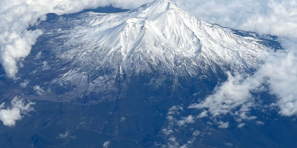
Mount Shasta presents a unique challenge that most other active volcanoes don't for USGS scientists. The only place to sample is near the summit of the active volcano located above 14,000-feet, meaning that scientists must also double as mountain climbers.
MOUNT SHASTA, Calif. – For some, Mount Shasta’s summit is a milestone. For others, it’s the office.
Mount Shasta presents a unique challenge for U.S. Geological Survey (USGS) scientists. With a peak over 14,000-feet, the only place researchers can collect critical samples on Mount Shasta is near the towering summit of California's largest active volcano, forcing researchers to double as mountain climbers.
The USGS and U.S. Forestry Service monitor and protect Mount Shasta—working in the daunting shadow of this geological work of art.
In their respective fields, Andy Calvert and Nick Meyers are two stewards of the magnificent stratovolcano located in the Cascade mountain range in Northern California. Together, the pair have over five decades of experience on Mount Shasta, and work to maintain and protect the mountain, which draws thousands of thrill-seekers to Siskiyou County each year to enjoy the outdoors.
On May 18, 1980, Dr. Andy Calvert collected his first rock sample from his front yard in northern Idaho as a seventh-grader – volcanic ash from the catastrophic eruption at Mount Saint Helens. Years later, after taking a geology class in college, Calvert pursued a career as a geologist that brought him to Russia, Alaska, Hawaii, Saudi Arabia and New Zealand, before ending up on the USGS Mount Shasta team.
What started as a summer internship with the U.S. Forestry Service for Nick Meyers at 19-years-old has led him to the role of Lead Climbing Ranger at Mount Shasta, where he has worked for more than 25 years.
WATCH: MOUNT SAINT HELENS ERUPTION IN 1980
Though Meyers describes Shasta as a beginner-friendly mountaineering objective, conditions can quickly turn dangerous—and often do. U.S. Forest Service rangers patrol the mountain daily, and when incidents occur, Meyers and fellow USFS climbers are on the front lines, carrying out high-risk, high-stress rescue operations on the volcano.
"Granted the weather and conditions are going well, a climb could go quite smoothly. It's about 6 ½ miles one way in 7,000 vertical feet, so it's definitely a trek. In the grand scheme of things, Mount Shasta is considered a little bit more of a novice endeavor, but it could certainly kill you and, despite being 15 minutes off of I-5, still has a lot of real mountain hazards," Meyers said.
Together, their teams work hand in hand to scale the imposing mountain, enabling scientists to collect the critical data needed to monitor the active volcano—all while navigating dangerous terrain. Scientists must not only climb over 14,000 feet, but also carry essential instruments and gather data throughout the expedition.
"Any opportunity we get to spend time with Andy and his cohorts is a total bonus… For us, our job could be a little bit like Groundhog Day: sharing safety and hazard-based information. To get that geologic perspective is really cool because we could share that with the visitors, it just provides a much more well-rounded experience for climbers," Meyers said.
Typically, on a USGS climb, the team of rangers and scientists embark on a two to three-day climb, Meyers said, climbing up the most common path known as the Avalanche Gulch Route when hoping to summit the volcano. The USGS crews collect samples from the summit roughly every two years – but often embark on "housekeeping" expeditions maintaining
On every expedition, weather is a critical factor. During summit missions, teams must carefully assess conditions to safeguard every crew member. In the high-alpine environment of Shasta's summit, dangerous conditions funnel in strong winds blended with frigid temperatures.
Mount Shasta is classified as a Very High Threat volcano under the National Volcano Early Warning System, necessitating constant monitoring. The USGS estimates its most recent eruption occurred roughly 3,500 years ago. Through ongoing observation, scientists can detect signs of renewed geologic activity—and, in worst-case scenarios, anticipate potential eruptions.
THIS ROCK IN ARCHES NATIONAL PARK WILL FALL, IT'S ONLY A MATTER OF TIME
The challenge Mount Shasta presents is unique and dangerous, but through a fluid partnership between the USGS and the U.S. Forestry Service – the team is able to gather essential data, keeping tabs on the future, while mapping the history of the volcano.
By understanding the volcanic history of Mount Shasta's past, researchers scaling Mount Shasta can better understand and predict what might happen in the future.
Calvert, whose specialty is dating rocks, said his team’s goal is to create a geologic, topographic map that reconstructs Mount Shasta’s long-term "family history"— identifying its past volcanic activity, and what it may reveal about future eruptions.
"I've got to collect from every lava flow I could get to on the volcano, and a lot of that involves Nick and his crew. They've been incredible partners over the years and when I need to get to some place, they help me get up there. Sometimes they collect the rock when I'm not there and bring it back. It's really been a great partnership," Calvert added.
According to the USGS, Mount Shasta formed atop an older volcano that collapsed 300,000–500,000 years ago. Since then, it has experienced long quiet periods punctuated by eruptions, including the formation of two of the volcano's four eruption cones, Black Butte and Shastina, about 11,000 years ago.
Smaller eruptions have occurred in recent millennia, with the most recent around 3,200 years ago. The volcano remains active, evidenced by hot springs and gas emissions, and is prone to mudflows and debris flows during heavy rain or glacial flooding.
LOOKING BACK AT JAPAN’S HISTORIC TSUNAMI DISASTER 15 YEARS LATER
Historically, eruptions occurred roughly every 600–800 years, though current monitoring shows low seismic activity and little ground deformation.
Combined, Meyers and Calvert share a lifetime of mountaineering experience, and the stories to prove it.
In the decades spent working on the field, Calvert recalled one of his favorite days spent on Mount Shasta, alongside Meyers some 13,000-feet up on the volcano.
"We sat down, and we had a candy bar, and I said, ‘Sometime I want to go over and get that dome over there.' It's steep, there's a glacier below it, it's a little bit harrowing," Calvert recalled.
The conditions lined up and without the condition, the trio embarked on a trek to the challenging dome on the north side of Mount Shasta.
"I went out and got the rock I needed. I dated it… I felt so safe because I was with these guys. Usually in places like that, I'm kind of on edge, but the conditions were perfect, Nick was on the other end of the rope, and I got the rock I needed. We went up to the summit and had the rest of the day. That day, that moment, is stuck in my mind as one of the best days of geologic field work I've ever had," Calvert said, adding that thanks to the excursion, researchers now know that the Hotlum Dome on Mount Shasta is roughly 10,700 years old.
For Meyers, his experience on Mount Shasta has found that the saying "Service is the highest calling" is true – "Whether it's cleaning toilets or emptying trash or saving someone's life when they think they're going to die or working with scientists, the connection to the community and the people is really what it's all about – protecting an amazing place like Mount Shasta, so people can enjoy it."
The post To study California’s largest active volcano, scientists first have to climb it appeared first on Fox Weather


