
 Apple TV + F1")

 Alexa+ Free with Prime get Nikki")


 hotels.com - US - Big Spring Sale")


Tornado threat increases as storms loom for millions across 10+ states just days after deadly outbreak
The renewed severe weather threat comes as many communities are still recovering from the devastating tornado outbreak late last week, raising concerns about additional impacts if storms redevelop across the region.
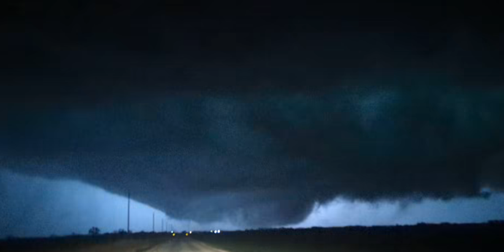
Severe weather across the Central U.S. isn’t letting up. The Heartland is bracing for another potentially deadly round of storms Tuesday, with the threat of intense tornadoes increasing just days after last week’s fatal outbreak.
As storm threats intensify, the Storm Prediction Center (SPC) has upgraded parts of Illinois and Indiana to a Level 4 out of 5 severe weather risk due to the risks for multiple intense EF-3+ tornadoes.
LIVE UPDATES: DANGEROUS STORM SYSTEM THREATENS MILLIONS WITH STRONG TORNADOES AND GIANT HAIL
And with a heightened risk of flooding due to rapid rainfall, Chicago is now under a Flood Watch.
More than 10 states are in the risk zone, placing millions of people in the potential path of damaging winds, large hail and strong tornadoes.
The renewed severe weather threat—spanning 1,500 miles from Texas to Michigan—comes as many communities are still recovering from the devastating tornado outbreak late last week, raising concerns about additional impacts if storms redevelop across the region.
At least 23 tornadoes ripped through the Heartland between Thursday, March 5, and Saturday, March 7, ranging in strength from EF-0 to EF-3, claiming the lives of eight people and leaving communities devastated in their wake.
The multi-day severe weather outbreak ripped through Texas, the Plains and the Midwest before it charged towards the Great Lakes and the Northeast.
Portions of those same areas are yet again in the zone for another round of intense severe storms that will continue into the evening.
A potent upper-level disturbance will track across the Northern Plains toward the Upper Midwest, set to bring a surge of strong aloft wind energy into the southern Great Lakes by late afternoon and evening.
Despite the strongest energy arriving after peak daytime heating, the environment will remain primed for severe thunderstorm development.
At the surface, a weak area of low pressure is expected to develop along a frontal boundary and track from northern Missouri into northwest Illinois by early evening, then move toward southern Lake Michigan overnight.
With temperatures set to increase throughout the afternoon, the atmosphere ahead of the system will increase the development of storms by late afternoon, particularly from northern Missouri into northern Illinois.
Favorable wind patterns will support the formation of supercells—rotating thunderstorms capable of producing severe weather.
These cells are expected to track eastward along and south of a warm front draped from northern Illinois into southern Michigan.
The FOX Forecast Center said north of that boundary, cooler air near the ground will limit surface-based storms.
In turn, the main concern there would be hail.
In this area, thunderstorms could produce large hail, damaging wind gusts, and tornadoes, with a few strong tornadoes possible, if storms remain isolated.
And this is where the most uncertainty comes into play for a place like Chicago.
While a Flood Watch has been issued, if the cooler air off Lake Michigan fights back, the warm front will never lift far enough into the city.
MOTHER, DAUGHTER TRAGICALLY KILLED DURING SEVERE WEATHER IN OKLAHOMA AMID MULTI-DAY OUTBREAK
Farther southwest across the southern Plains, another area of concern will develop as a strong upper level storm system moves east from the Baja Peninsula into northern Mexico and eventually west Texas.
Strong daytime heating across northeast Mexico and areas near the Texas-New Mexico border, extending north into western Kansas, will help make the atmosphere increasingly unstable.
By late afternoon, thunderstorms are expected to develop quickly along the dryline boundary — which separates dry air to the west from more humid air to the east — continuing into the evening.
WHAT IS A SUPERCELL THUNDERSTORM?
Some storms could rapidly become supercells capable of producing very large hail — likely at least softball-size, as cooler air will remain higher in the atmosphere, with strong instability near the ground.
As the evening unfolds, the strengthening system is expected to organize into a larger line or cluster, potentially shifting more toward damaging winds as storms merge into a squall line moving east.
Dallas-Fort Worth is right on the edge of the highest severe threat level.
The bulk of the storms should move into the metro later tonight, but isolated storms earlier in the day are possible.
In turn, this will create a broad warm sector across the region — an area of warm, unstable air — that can support strong thunderstorms.
RELATIVE DETAILS THE MOMENTS MOTHER AND DAUGHTER WERE TRAGICALLY KILLED IN OKLAHOMA TORNADO
Within this large zone, there is a narrow corridor being monitored in Illinois and Missouri, where a Level 4 out of 5 threat is now in place.
DEADLY TORNADO DEVASTATES UNION CITY, MICHIGAN, CARVING A PATH OF HEARTBREAKING DAMAGE IN COMMUNITY
The FOX Forecast Center highlights these cities for the top severe weather threats as a Level 4 out of 5 severe weather risk has been issued for them: Joliet, Peoria, Bloomington, Illinois; Rensselaer, Indiana.
A Level 3 out of 4 threat has been issued for the following: Chicago, Illinois; Fort Worth, Abilene, Del Rio, Wichita Falls, Texas and Lawton, Oklahoma.
And a Level 2 out of 5 threat remains for Dallas, Texas; Detroit, Michigan; Indianapolis; Oklahoma City and Tulsa, Oklahoma; Kansas City, Missouri.
The post Tornado threat increases as storms loom for millions across 10+ states just days after deadly outbreak appeared first on Fox Weather


