



1 remains missing following devastating flooding in Missouri, with more storms, heavy rain on the way
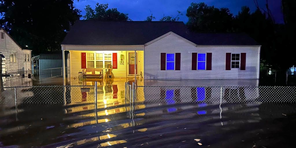

Following a day of intense flash flooding across the Heartland, the threat of both severe thunderstorms and flash flooding continues into Saturday.
Following a day of intense flash flooding across the Heartland, the threat of both severe thunderstorms and flash flooding continues into Saturday.
Many of the same areas will experience additional rainfall and possible flooding, with the threat expanding farther south.
On Friday, a Flash Flood Emergency was issued across Iron and Reynolds counties in Missouri, where rain totals reached as high as 12.25 inches.
The Missouri Regent C Incident Command tells FOX Weather that more than 351 rescues were performed as of 9:45 p.m. on Friday.
Of those rescues were 200 children from Camp Taum Sauk, which were relocated to St. Louis last night.
According to the Crawford County Sheriff's Office, a woman is missing after floodwaters entered her home.
The woman and her boyfriend called dispatch for assistance as the waters quickly rose around 3 a.m. As they tried to escape, a wall of the home collapsed and swept the woman away.
The search for the missing woman is resuming on Saturday morning.
"We'll continue with the ground search," Major Adam Carnal, the undersheriff of Crawford County Sheriff's Office, told FOX Weather. "We're using drones for an air search, and by water, as well, if able to."
The Weather Prediction Center continues to highlight a "concerning" heavy rainfall forecast across the Mississippi, Tennessee and Ohio Valleys on Saturday, with the overall pattern not expected to change much.
A strong ridge of high pressure over the Four Corners is causing an upper-level trough to slow as it moves east. With this, a cold front will sag through the Mid-Mississippi and Tennessee Valleys before stalling in a west-to-east orientation come Sunday morning, bringing repeated rounds of moisture and disturbances from the Southern Plains into the Mid-Atlantic through the weekend.
KNOW YOUR FLOOD TERMINOLOGY: WHAT FLOOD WATCHES, WARNINGS AND EMERGENCIES REALLY MEAN
Flood Watches remain in effect, along with a Level 2 out of 4 flash flood risk through Saturday across portions of southeast Missouri, Kentucky, Tennessee and West Virginia.
Rainfall totals of 2-3 inches are expected through Sunday from southern Illinois into Kentucky and central Tennessee.
Rounds of thunderstorms will repeatedly move over cities like St. Louis and Nashville, which could see rain totals between 3-5 inches.
Come Sunday, the flood threat shifts east into eastern Tennessee, western North Carolina and parts of southern Virginia. A Level 2 out of 4 flash flood threat is in place from east of Nashville to the coast of North Carolina.
As the ridge of high pressure over western U.S. moves into the northeastern tier early next week, a setup for heavy rainfall will develop along the Gulf Coast.
HERE'S WHAT TO DO IF YOU ENCOUNTER A FLOODED ROAD
Deep tropical moisture and several disturbances will move in and create an environment of repeated rounds of thunderstorms along the southern edge of the ridge.
These storms are capable of producing torrential rainfall, triggering flash flood threats.
The greatest threat here is across eastern Texas and Louisiana, where a Level 2 out of 4 flash flood threat is in place through Monday. This includes cities like Houston and New Orleans.
A broader Level 1 out of 4 threat will extend more than 1,000 miles from western Texas to the South Carolina coast.
Through Tuesday, widespread expected rainfall totals are expected across eastern Texas, Louisiana and southern Mississippi.
The post 1 remains missing following devastating flooding in Missouri, with more storms, heavy rain on the way appeared first on Fox Weather