



Relentless storms continue to target Midwest, Ohio Valley following deadly week of wind, flash flooding
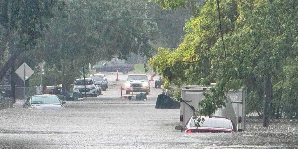


Millions across parts of the Midwest and Ohio Valley are bracing for another round of thunderstorms and flash flooding Thursday on the heels of Flash Flood Emergencies that prompted numerous water rescues in Indiana Wednesday and a deadly windstorm that swept across the region earlier this week.
THE TAKEAWAY
Millions across parts of the Midwest and Ohio Valley are bracing for another round of thunderstorms and flash flooding Thursday on the heels of Flash Flood Emergencies that prompted numerous water rescues in Indiana Wednesday and a deadly windstorm that swept across the region earlier this week.
Relentless storms will develop and move along a stalled weather front, with the potential for periods of heavy rain lasting through the weekend.
Indiana Gov. Mike Braun declared a Statewide Disaster Emergency Thursday to free up additional resources after a week of extreme weather.
Some state roads and communities in eastern Indiana were still flooded Thursday morning after five Flash Flood Emergencies were issued Wednesday across that part of the state.
More than 400,000 customers were still without power Thursday afternoon across parts of Illinois, Indiana and Ohio.
Many of the lingering outages stem from Tuesday's deadly derecho, which knocked out power to more than one million customers at the height of the windstorm.
A strong cluster of thunderstorms developed over parts of Nebraska and Iowa early Thursday, prompting Tornado Warnings. That system is expected to track across Illinois and Indiana through the day.
16 HOSPITALIZED AFTER LIGHTNING STRIKE AT OHIO PRISON; ALL VICTIMS IN STABLE CONDITION
NOAA's Storm Prediction Center (SPC) has issued a Level 2 out of 5 risk of severe thunderstorms across central and southern Iowa to central Illinois, including Des Moines, Peoria and Springfield.
A broader Level 1 threat stretches from the Central Plains into the Midwest and southern Ohio Valley, including parts of Iowa, Missouri, Illinois, Kentucky and already-inundated Indiana.
Damaging wind gusts will be the primary threat from any severe thunderstorms that develop.
However, these storms will track over waterlogged Indiana, prompting the NOAA's Weather Prediction Center (WPC) to issue a Level 3 out of 4 risk of flash flooding for the central and southeastern parts of the state.
This includes Indianapolis, as well as the western half of Cincinnati, Ohio.
A second round of heavy rain is expected to develop over this area Thursday night into Friday morning, potentially bringing an even greater threat as storms repeatedly track over the same locations.
Chicago and Pittsburgh are under a Level 2 flash flood risk through Friday morning.
FLASH FLOOD EMERGENCIES ISSUED ACROSS INDIANA AS LIFE-THREATENING FLOODING LASHES THE STATE
Flood Watches are in place across portions of Indiana, Ohio, West Virginia, northeast Kentucky, western Virginia, Pennsylvania, North Carolina and east Tennessee through Friday.
River flooding will remain a threat across Indiana over the next three days, with the National Weather Service issuing Flood Warnings for communities along swollen rivers.
According to the FOX Forecast Center, widespread rainfall totals of 1 to 2 inches are likely, with locally 2 to 3 inches or more possible.
The threat began on Monday and ramped up into the day on Tuesday, when a damaging derecho was confirmed across the Midwest and Ohio Valley as intense winds knocked out power for over a million customers across half a dozen states.
MEET THREEHALVES: THE HAUNTING VIRAL ROBOT DESIGNED FOR EARTH'S MOST DANGEROUS ENVIRONMENTS
The FOX Forecast Center said Tuesday's storms were confirmed to be a derecho. In order to be classified as a derecho, a storm needs to stretch at least 250 miles long and be at least 60 miles wide.
At its peak, Illinois, Indiana and Ohio all had over 300,000 customers without power each, while Kentucky was also impacted enough to knock out power to over 100,000 customers.
The strongest wind reports were concentrated across northeastern Illinois and the Chicago area, with several gusts approaching 100 mph through midday Tuesday. Sugar Grove recorded the highest gust at 97 mph, followed by Shorewood at 96 mph, while Bradley and Mokena each reported gusts of 91 mph.
Damaging winds swept into Illinois, triggering Tornado Warnings across several areas Tuesday afternoon — including Aurora, Joliet, Naperville and downtown Chicago.
A 4-year-old was killed when a tree fell on a home in Geneva Township, Indiana, during severe storms on Tuesday, according to the Jennings County Sheriff's Office.
Torrential rain prompted the National Weather Service (NWS) to issue several Flash Flood Emergencies for life-threatening flash flooding across east-central Indiana late Wednesday morning.
The NWS also issued Flash Flood Emergencies in Indiana in parts of Delaware, Fayette, Union, Wayne and Franklin counties Wednesday, with some remaining in effect through the afternoon.
Some of the highest rainfall totals since Monday have been reported across Indiana and Ohio, where several locations have received more than half a foot of rain.
FLOOD WATCH, WARNING AND EMERGENCY: HERE ARE THE DIFFERENCES THAT COULD SAVE YOUR LIFE
The Delaware County Sheriff's Office said Thursday it resumed the search for a missing swimmer after receiving a report Wednesday night that four people had jumped from a bridge into a river. Officials said the other three were recovered safely that evening.
In Perry County, Ohio, more than 6.5 inches of rain fell in just a few hours, flooding numerous roads, including in downtown Crooksville, triggering a Flash Flood Emergency.
The flooding turned deadly, on Wednesday, Ohio Gov. Mike DeWine confirmed one person was killed after emergency responders were unable to reach the individual during a flooding emergency.
The post Relentless storms continue to target Midwest, Ohio Valley following deadly week of wind, flash flooding appeared first on Fox Weather